Production workflows / Guide 39
An Insurance Weather Risk Agent That Does Not Confuse Alerts with Loss
Build an insurance weather risk agent that joins forecasts to insured exposure, separates hazard from loss, and preserves evidence for human underwriting review.
Illustrative engineering guide. Examples are not client deployments, production-ready integrations, or evidence of measured results. Validate the design with your domain and security owners.

Imagine a hypothetical insurer reviewing a portfolio of commercial properties before a severe storm. A weather alert intersects a large area, but insured buildings differ in location accuracy, construction, occupancy, and coverage. Multiplying every policy limit by a guessed damage percentage produces an impressive number with little defensible meaning.
An insurance weather risk agent should prepare exposure briefings and prioritize human review. It should separate the chance of a hazard, the assets exposed, physical vulnerability, policy coverage, and eventual insured loss. These are connected questions, not interchangeable labels. The assistant must not autonomously deny coverage, change premiums, or settle claims.
Define the decision horizon
Operational storm monitoring and long-term underwriting need different evidence. A short-range forecast may support outreach or staffing decisions. It does not by itself describe the annual loss distribution of a property. Likewise, a historical hazard score is not proof that a particular building suffered damage yesterday.
For a first implementation, choose one question: which insured locations require review for a named event, and what evidence supports that queue? Keep catastrophe loss estimation outside scope until an approved hazard and vulnerability model is available. A transparent exposure list is more useful than an unsupported portfolio loss forecast.
Record policy effective dates, covered locations, insured values, deductibles, limits, endorsements, and coverage version. Do not join weather to a billing address when the insured property is elsewhere. Keep geocoding confidence and unresolved addresses visible; dropping unmatched properties makes exposure look artificially low.
Preserve weather semantics
The NWS API documentation describes forecasts, alerts, observations, and their data lifecycle. It notes that location-to-grid mappings can change and that observations can be delayed. Store source identifiers, issue times, valid intervals, geometry, units, and retrieval times rather than retaining only a natural-language forecast.
An alert polygon is a screening boundary, not a damage footprint. A property just outside it should not be labeled risk-free. A missing polygon may require an approved zone-based interpretation rather than silently excluding the alert. These choices belong in versioned geospatial rules reviewed by risk specialists.
Use deterministic spatial joins with a known coordinate reference system. Keep the reason for each match: point inside geometry, buffer intersection, or unresolved address requiring manual review. Avoid allowing the language model to decide whether latitude and longitude “look close enough.”
A minimum evidence workflow
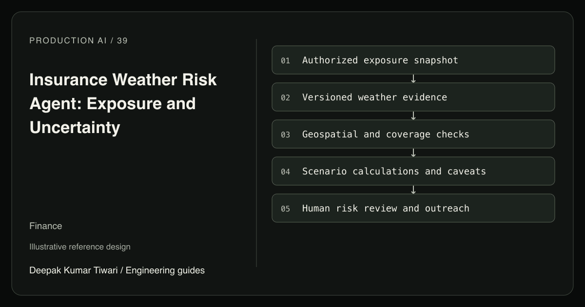
Read a tenant-scoped exposure snapshot and approved weather feed. A geospatial service produces candidate matches and data-quality flags. A policy service identifies relevant effective coverage without deciding the claim. The model drafts a brief that separates observed facts, scenario assumptions, and unresolved questions.
A risk analyst approves outreach and any internal escalation. A separate notification service sends approved messages without altering policy terms. Specialist agents may help if distinct perils require different source interpretation, but each must return typed evidence into one portfolio record. They should not negotiate a shared loss number through conversation.
When an approved model supplies ground-up loss scenarios, financial terms can be evaluated deterministically. The following illustrative Python function shows only a simple per-occurrence deductible and insurer-payment cap. It is not a catastrophe model or a general insurance contract interpreter.
from decimal import Decimal

def simple_insured_loss(ground_up, deductible, payment_cap):
    values = tuple(Decimal(str(v)) for v in
                   (ground_up, deductible, payment_cap))
    if not all(v.is_finite() and v >= 0 for v in values):
        raise ValueError("invalid_loss_terms")
    gross, excess, cap = values
    return min(max(gross - excess, Decimal("0")), cap)

assert simple_insured_loss(8000, 10000, 50000) == 0
assert simple_insured_loss(80000, 10000, 50000) == 50000
Production requires validated currency, policy interpretation, peril definitions, aggregates, sublimits, coinsurance where applicable, and event aggregation rules. The source of ground_up must be an approved scenario model or verified assessment, never the LLM’s intuition. Applying a deductible to an average ground-up loss generally does not produce the average insured loss because financial terms are nonlinear.
Keep scenario identifiers and probabilities, when valid probabilities exist. If inputs are merely low, central, and high illustrations, label them as scenarios rather than percentiles. Do not invent a confidence interval to make uncertainty look quantified.
Revisions and recovery are financial controls
Bind each briefing to an exposure snapshot, weather version, geospatial rule version, and model version. A forecast update should create a new briefing revision with changed locations and assumptions. Preserve the old version so analysts can explain what was known when outreach was approved.
If exposure ingestion fails halfway through a portfolio, mark the run incomplete and block a portfolio-wide conclusion. Retrying a read should resume from a durable checkpoint without double-counting locations. Concurrent snapshot publication needs consistent transaction handling; PostgreSQL’s isolation documentation explains the relevant local consistency boundaries.
For outreach writes, use an event, policy, recipient, and approved-message-version key. A retry should not send the same warning repeatedly. If delivery status is ambiguous, reconcile provider receipts or route to an operator. Never let a failed notification become an automatic policy change.
Control access and consequential decisions
Authenticate analysts server-side and scope exposure retrieval by tenant, portfolio, and role. Exact property coordinates and insured values are sensitive commercial data. Public weather can be cached broadly, but joining it to private exposure creates a restricted dataset. Do not send raw portfolio data to unapproved geocoding or model services.
Uploaded surveys and broker notes are untrusted content. OWASP’s LLM security project motivates keeping their instructions outside tool authority. MCP is integration, not permission to modify policies. Underwriting and claims decisions require accountable human review, applicable governance, and fairness checks; do not infer protected traits or use neighborhood descriptions as covert substitutes.
Acceptance tests with adversarial evidence
- Match a billing address but not the insured location. Expect rejection of the join and a location-quality task.
- Ingest an expired alert after a newer one. Expect historical retention without promoting it to the active briefing.
- Provide a loss scenario without model provenance. Expect no insured-loss estimate and an explicit missing-evidence warning.
- Fail exposure loading halfway through a portfolio. Expect incomplete-run status and no portfolio-wide risk conclusion.
- Replay an outreach command and include a premium-change instruction in a survey. Expect one logical notification and no policy write.
Measure screening quality, not imaginary loss accuracy
Baseline analyst preparation time and manually verified event-exposure queues. Measure screening recall as correctly surfaced relevant locations divided by all relevant locations in the reviewed reference set. Measure precision as relevant locations divided by all surfaced locations, and report unresolved geocodes separately rather than excluding them quietly.
Guardrails include omitted high-priority exposure, unsupported coverage statements, duplicate outreach, and unequal error rates across relevant portfolio segments. Begin with historical event replay, then shadow live monitoring, then approved outreach for one peril and region. Loss-model performance requires a separate validation program and must not be claimed from briefing quality.
Start with address quality and evidence-linked exposure screening. Insurance claims assistance begins after reported loss and needs different evidence; agriculture advisory uses weather for field decisions rather than insurance pricing. Data engineering services can establish the reproducible joins and snapshots that make this distinction operational.